Come along to No 28 on January 2nd and try Urban orienteering! For those of you who’d like to know a little bit more about the Belper map, I’ve written this post. Read it, and I guarantee it’ll save you 5 or 10 minutes on Jan 2nd if you’re new to orienteering ; )

Poster for the Belper Urban race – the course is just a made-up example to give an idea of how orienteering works in a town. The green is private land, which you cannot cross, so the distances on Urban courses are always 20-30% longer than advertised!
Orienteering came to the UK from Sweden in the 1960s, so the first thing to say about ‘O’ maps is that the symbols are international. Top-end orienteers compete world wide, and even recreational orienteers will often plan a holiday around a multi-day event in an exotic location. I’ve orienteered in the four Scandinavian countries, France, Hungary, Switzerland, Lithuania, the USA, Australia and New Zealand!
In O maps, use of colour is counter-intuitive, as we map runability, not what’s actually on the ground. This helps orienteers make route-choice decisions: is it quicker to run though forest with brambles, or go three sides of a square, but along a path? So there’s a continuum from white through to dark green, with white being runable forest, light green denser forest (we call it ‘forest walk’) to dark green ‘forest fight’ – rhododendrons, gorse, holly or felled trees where you have to crawl under or climb over the trunks. Don’t go there if at all possible!
Open land (grass) is mapped as yellow and again there’s a continuum of this to white, so that a few scattered trees on grass is mapped as yellow with regular white spots, in something we call ROST (rough open with scattered trees). Are you enjoying the lingo so far?!

St Peter’s Church Yard, showing the rough open scattered trees (ROST) symbol. The white round the edge is continuous trees.
You can see that there’s quite a lot here that’s open to interpretation, and although I’ve been orienteering for 27 years, I would find mapping a forest just too daunting.
In 2001 our club Derwent Valley Orienteers (and all 120 O clubs in the UK) were unable to hold competitions on many of our countryside areas due to sanctions to control the foot and mouth outbreak. So orienteers began mapping towns and cities to hold events there.
Urban orienteering offers the same challenges of planning and executing a route while running at speed that normal orienteering poses. Orienteering has been compared to playing chess while sprinting, and mistakes are made because oxygen debt builds up when you are running too fast and misinterpret the map.
This year I’ve done Urban races in Edinburgh, Whitby, Grimsby, Manchester, Liverpool and Todmorden. I’m quite evangelistic about the excitement of Urban, and got it in The Guardian Weekend Magazine’s Body: How I Work It column in September. The journalist did a great job, as did the photographer, who was jetting off to LA to shoot will.i.am two days after my photoshoot! Does anyone recognise where the photo was taken?
DVO has mapped Chesterfield, Matlock, Wirksworth, Ripley and Ashbourne for Urban orienteering. Our best non-urban areas are Eyam Moor, Birchen Edge, Stanton Moor, Chinley Churn (photos from our September event), Crich Chase and Shining Cliff Woods (we have an event there 29th January 2017). We have a lot more areas mapped, but these latter are of such a technical standard they would pull orienteers from all over the country. Lower down the scale we have a number of parks and grounds of National Trust properties, which are great for beginners.

This poster shows areas where DVO has held events in 2016. I’m working on one for 2017 now!
I’ve lived in Belper for 20 years and offered to map it for the club’s annual New Year Urban event (2nd January 2017). I find Urban racing much easier than forest running as buildings are either there, or not there. There’s nothing half-way about a building, whereas with contours we have a half-contour symbol called a form line, which looks like a contour, but is dashed. Contours are mapped at 5 metre intervals, and the form line is used for prominent features not big enough to merit a contour.
So Urban mapping is largely a case of tracing streets and buildings from a base map, using a CAD package called, yes, you’ve guessed it, O-CAD. The only skills needed are persistence and attention to detail, as even the curb edges are mapped, as well as things like islands at road crossings.
I started the map in January 2016 and had a couple of O-CAD lessons from Mike, DVO’s mapping supremo. The scale of an Urban orienteering map is 1:5000. Compare this to the OS Explorer maps at 1:25000 and you can see that it’s a lot more detailed. A square km on Explorer is 4cm x 4cm, but on an Urban O map it’s 20cm x 20cm. Every building is shown remarkably clearly. Grass verges are mapped, as are individual trees in town streets.
The first job was to trace the buildings, which took a couple of weeks. The next step required more thought. Remember I said that conventional orienteering map symbols represent runability? The Urban symbol set represents permissability. Private land (gardens etc.) are shown as olive green and public tarmac’d areas as pale brown. Grass is yellow, runable forest is white, as in forest O.

The Clusters, Christ Church, Belper Library, Green Lane and Mill Street
You can see Belper Library at the bottom left, above. Each tree at the front is shown, the grass behind is shown as yellow, with the trees as white. The single tree on the lawn is shown as a small green dot (trunk circumference less than 30cm). Of course it’s a bigger green dot for larger trees, like the oak just showing on the southern tip of The Triangle. You can see Long Row playground marked with the pink out-of-bounds symbol, rather than olive green. This is because it’s useful to show for navigation purposes, even tho you can’t cross it.
Walls and fences have two symbols depending on whether they are crossable or uncrossable. Not physically crossable, note, but whether or not you are allowed to cross them! Yes, it’s confusing and, yes, people do get disqualified (58 people were disqualified for crossing out-of-bounds wild-flower meadows at the British Sprint Championships at the Olympic Park this year; not me tho, I got 3rd place in my age group!). Anyway these are the rules and the sport must be fair.
So once all the buildings are traced onto the map, the next step is the boundaries of the private land, shown in olive. Technically this should be an uncrossable wall or fence, but because you’re not allowed to cross olive, adding a bold black line around it would be overkill (the map looks less cluttered if only essential or helpful symbols are used). So we use the thin black line that denotes a ‘step or edge of paved area’. The uncrossable wall symbol is used round the railway in the Clusters extract above, and uncrossable fence is used at the edge of the football pitch.
Next come the outlines of the roads and pavements, and this is done with Google Street View open on another laptop. It’s a very time consuming job to get the curves nice and smooth! Then there’s adding the colour, which can be done quickly if it’s simply a case of filling in a closed area, but often it isn’t that simple.
All told, I must have spent about 300 hours on the map, spread over 6 months. During the last 2 months I was checking the map on the ground, scrawling amendments onto a tracing paper overlay and taking photos, and then amending it on the computer. When I handed the file back to Mike in June, I felt like I’d got my life back, and I’m very grateful for all the hours he’s put in this autumn checking things.
Not all his changes are things I’ve missed, however! New features do appear, cases in point being the new B&M/Aldi store and the trim trail up on the Parks.
Once working version of the map is available, I started planning the seven courses that we’ll offer on January 2nd. The longest course, Men’s Open (for men age 21-34) will be 7.5 km with roughly 25 checkpoints, and the shortest will be for Juniors under 12, maybe 2 km, with about 15 checkpoints. We use a program called PurplePen for this, and I’ll discuss the courses in detail with the race controller, who will suggest improvements and advise on safety. For instance, the two longest courses will likely go into the River Gardens, so to avoid people running across the A6, I’ll have a timed-out crossing at some pedestrian lights, with checkpoints either side. Electronic timing means that the time taken to cross can easily be deducted.
The Belper event is on January 2nd from No 28 The Market Place, and everyone will start at 11am (this ‘mass start’ is quite unusual in orienteering, but we always use it at our New Year events because it means you have longer to put out all the checkpoints in the morning, and people are generally back by 12 or 1pm).
You can see what events we have coming up on our Facebook page (go on, have a look & give us a Like!), or on the Fixtures tab of the DVO website. British Orienteering have a great Guide for Newcomers and I love the fact that our sport needs its own dictionary! Do you know what a re-entrant is?!
Entry to the Belper Urban costs just £3.50 for Courses 6 and 7, which have been planned for Juniors, families and Adult Beginners.
The longer courses cost £8 to enter on the day (£7 if you enter online before Dec 28th, see link below), still £3.50 for Juniors/Students. The event is part of the UK Urban League, in which orienteers compete against others in their age group. We have an online entry system as there’ll be more competitors from further afield.
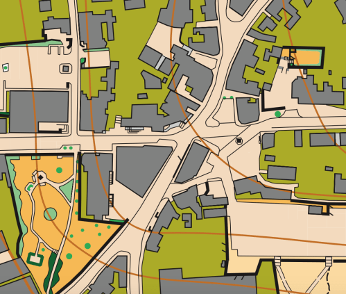
The Market Place area, from where the event will start. In the top right, the Nag’s Head kindly allowed me to map their beer garden! And I’ve got permission from Belper Town Council to put a checkpoint or two in the Memorial Gardens (bottom left). I’ve had to ask Mike to add the Prominent tree symbol for the Christmas tree!

Leave a comment